


Imago Mundi
Oldest Map of the World- (now Iraq)

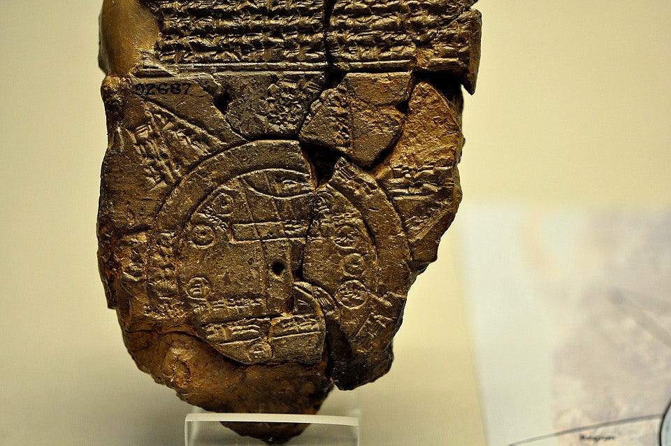
The Babylonian Map of the World (also Imago Mundi or Mappa mundi) is a Babylonian clay tablet with a schematic world map and two inscriptions written in the Akkadian language.
The cuneiform map depicts Babylon, the Euphrates, and the “Bitter River,” as well as the eight triangular nagû, which likely represent mythological regions. The map is situated within Mesopotamian cosmic geography and reflects a worldview blending empirical and mythical elements.1 A missing part was identified by Edith Horsley, a volunteer at the Museum.2
Babylon today is an archaeological site in modern-day Iraq, about 85 kilometers south of Baghdad.
Imago Mundi: International Journal for the History of Cartography
The map is used as the logo of the academic journal, Imago Mundi: International Journal for the History of Cartography.3 Imago Mundi is the only English-language journal dedicated to the history of pre-modern maps and cartography. A 1982 article provides a comprehensive survey of cartographic artifacts from ancient Mesopotamia, including the Babylonian Map of the World and other cuneiform-based maps situated within the broader context of Mesopotamian administrative and religious practices.4
The Babylonian Map of the World with Irving Finkel
Irving Finkel is an English philologist and Assyriologist. He is the Assistant Keeper of Ancient Mesopotamian script, languages and cultures in the Department of the Middle East in the British Museum, where he specializes in cuneiform inscriptions on tablets of clay from ancient Mesopotamia. (He is on the editorial board of Board Game Studies). Finkel owns a replica set of the Lewis chessmen which were used as props in the first Harry Potter film.5
Horowitz, W. (1988). “The Babylonian Map of the World.” Iraq, 50, 147–165.
Finkel, I. L. (1995). A Join to the Map of the World: A Notable Discovery. British Museum Magazine, 5, 26–27.
Imago Mundi, founded in 1935 by Leo Bagrow, is the only English-language journal dedicated to the history of pre-modern maps and cartography. See also: Smith, Catherine Delano, "Imago Mundi’s Logo the Babylonian Map of the World," Imago Mundi, vol. 48, pp. 209–11, 1996.
Millard, A. R. (1982). “Mesopotamian Maps: A Survey of Cartographic Evidence from the Second Millennium BC.” Imago Mundi, 34(1), 2–12.
(see above). Also, see Madden, F. (1832). "Historical remarks on the introduction of the game of chess into Europe and on the ancient chessmen discovered in the Isle of Lewis." Archaeologia, 24, 203–291.
Really interesting. Irving Finkel couldn't look more appropriate for his titles! 😊
New to me! Thank you!